Clear Lake Area History
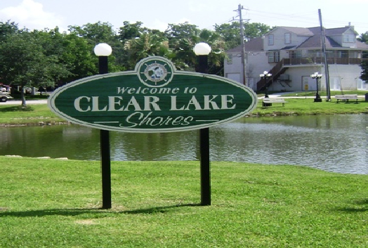
Clear Lake Shores History
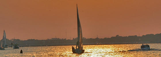
Clear Lake Shores is an island community on the south shore of Clear Lake, with an interesting history which adds to the mystique of this diverse neighborhood. The town has two bridges to the main thoroughfares and is surrounded by Clear Lake. Quaint bungalows with wraparound porches sit peacefully beside fancy new mansions on stilts in this waterfront city. What started off as a small fishing village of weekend homes is now home to mostly permanent residents. Now, new homes are being built all over the island.
Two brothers, Arthur and Warren Smadbeck, teamed up with a newspaper to promote the resort colony and developed Clear Lake Shores in 1926. Along with a subscription to the Houston Post-Dispatch, you could get a 20’ by 100’ lot for $69.50, at $9.50 down and $3.00 per month. Old timers have passed down a story about one of the lots being given away as a door prize at a dance during the 1930’s because the owner of the lot could not afford to pay his 50 cents per lot annual dues. Potential buyers gathered at the Clubhouse in April 1927 and all 2,400 lots were purchased. Taxes on the property in 1928 were 15 cents a lot, and unlimited water use was made available to each house for $1.00 per month. The newspaper ads told readers that “values of the property are bound to increase.”
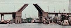
Incorporated as a city in November 1962 to fend off encroachment by Texas City, Clear Lake Shores has a 20 mile per hour speed limit and ducks, golf carts, and children have the right-of-way. Many residents like to tool around the town’s narrow patchwork of streets on golf carts. Clear Lake Shores has seen many changes – from a time when it was sparsely populated during the Depression, to today, when houses up to 7,000 square feet have been built along the lake. The city, which is a bird sanctuary, is home to 1,443, and has 1,500 boat slips. Some choose live on their yachts at the city’s three marinas – Watergate, Portofino and Legend Point. The U.S. Senate has named Clear Lake Shores as, "The Yachting Capital of Texas" because city has more boat slips than people.
Many homes in Clear Lake Shores come with boat slips surrounding the island. The shoreline lots are leased to residents for 10-year periods. This was done originally because the city could not afford to bulkhead the entire island. Leaseholders are responsible for the bulkhead and many keep 10’ to 40’ boats at their waterfront. One of the benefits is that many interior homes have boat slips and their own little piece of the waterfront. Clear Lake Shores also has water front parks to enjoy. Overall, all residents have a water view every time they drive to and from home. There are also some great restaurants such as Joe Lee’s Kitchen, and Skippers. There is even a local pub, The Sandbar.
Part of the history of this village is the Clubhouse. Strains of jukebox music, wedding vows and shouts of political turmoil have bounced of the weathered walls. The 63
year-old building has seen a mayor impeached in a bitter feud that divided this lakefront town, but it has also been a place for residents to forget their political differences and gather for annual pre-Thanksgiving feasts, impromptu Saturday night dances and many weddings. It has had many uses throughout the years, including serving as a temporary morgue after the April 16, 1947, explosion of the ship SS Grandcamp in Texas City, which killed more than 500 and injured thousands. It may be the oldest public building still in use on the Galveston County mainland.
Clear Lake Shores has the characteristics of a small town. During one hurricane when the electricity was out, the police chief went from house to house to pick up thawing meat for a city-wide barbecue. Residents gather for the Clear Lake Christmas Boat Parade, Fireworks, Thanksgiving Buffet and other events.
Clear Lake Shores is a truly historic, eclectic community in a quickly developing neighborhood. Nearby, Kemah is becoming a major attraction and houses continue to be built in South Shore Harbour, Kemah, Clear Lake Shores and Seabrook every day. Home prices continue to rise and the community spirit is alive and well. For living on the waterfront, Clear Lake Shores offers it all.
Two brothers, Arthur and Warren Smadbeck, teamed up with a newspaper to promote the resort colony and developed Clear Lake Shores in 1926. Along with a subscription to the Houston Post-Dispatch, you could get a 20’ by 100’ lot for $69.50, at $9.50 down and $3.00 per month. Old timers have passed down a story about one of the lots being given away as a door prize at a dance during the 1930’s because the owner of the lot could not afford to pay his 50 cents per lot annual dues. Potential buyers gathered at the Clubhouse in April 1927 and all 2,400 lots were purchased. Taxes on the property in 1928 were 15 cents a lot, and unlimited water use was made available to each house for $1.00 per month. The newspaper ads told readers that “values of the property are bound to increase.”
Incorporated as a city in November 1962 to fend off encroachment by Texas City, Clear Lake Shores has a 20 mile per hour speed limit and ducks, golf carts, and children have the right-of-way. Many residents like to tool around the town’s narrow patchwork of streets on golf carts. Clear Lake Shores has seen many changes – from a time when it was sparsely populated during the Depression, to today, when houses up to 7,000 square feet have been built along the lake. The city, which is a bird sanctuary, is home to 1,443, and has 1,500 boat slips. Some choose live on their yachts at the city’s three marinas – Watergate, Portofino and Legend Point. The U.S. Senate has named Clear Lake Shores as, "The Yachting Capital of Texas" because city has more boat slips than people.
Many homes in Clear Lake Shores come with boat slips surrounding the island. The shoreline lots are leased to residents for 10-year periods. This was done originally because the city could not afford to bulkhead the entire island. Leaseholders are responsible for the bulkhead and many keep 10’ to 40’ boats at their waterfront. One of the benefits is that many interior homes have boat slips and their own little piece of the waterfront. Clear Lake Shores also has water front parks to enjoy. Overall, all residents have a water view every time they drive to and from home. There are also some great restaurants such as Joe Lee’s Kitchen, and Skippers. There is even a local pub, The Sandbar.
Part of the history of this village is the Clubhouse. Strains of jukebox music, wedding vows and shouts of political turmoil have bounced of the weathered walls. The 63
year-old building has seen a mayor impeached in a bitter feud that divided this lakefront town, but it has also been a place for residents to forget their political differences and gather for annual pre-Thanksgiving feasts, impromptu Saturday night dances and many weddings. It has had many uses throughout the years, including serving as a temporary morgue after the April 16, 1947, explosion of the ship SS Grandcamp in Texas City, which killed more than 500 and injured thousands. It may be the oldest public building still in use on the Galveston County mainland.
Clear Lake Shores has the characteristics of a small town. During one hurricane when the electricity was out, the police chief went from house to house to pick up thawing meat for a city-wide barbecue. Residents gather for the Clear Lake Christmas Boat Parade, Fireworks, Thanksgiving Buffet and other events.
Clear Lake Shores is a truly historic, eclectic community in a quickly developing neighborhood. Nearby, Kemah is becoming a major attraction and houses continue to be built in South Shore Harbour, Kemah, Clear Lake Shores and Seabrook every day. Home prices continue to rise and the community spirit is alive and well. For living on the waterfront, Clear Lake Shores offers it all.
Kemah
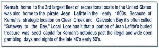

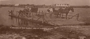
Kemah is on State Highway 146 and State Highway 96 in a half-moon pocket on Galveston Bay twenty-five miles northeast of Galveston in northeastern Galveston County. The Southern Pacific had been built passing through a small settlement and with the railroad came more people. About 1898, the Bradford & Kipp families, owners of almost all land, subdivided it into lots establishing the township of Evergreen. It was also known as Shell Siding in the period when the railroad hauled shell from the area. Along the shoreline of the Bradford property there extended a shell reef several hundred feet long, extending into the bay a couple of hundred feet. It is reported that in some places the shell was some 20 to 30 feet high. During the 1890's Bradford sold the shell to the railroad at seventy-five cents per rail car. The railroad built a spur track across the prairie from Dickinson to the bay to haul away the shell. There is some evidence of isolated sales of shell sold in 1875, which was hauled away by barge to Galveston for roads in that city. Indian Burial grounds were also found in the shell reef.
J.H. Kipp attempted to obtain a post office for Evergreen but was turned down because there was already a town of Evergreen. Summer residents were asked to come up with a name and "Kemah" was chosen, an Indian word meaning "wind in the face". It was officially renamed Kemah, for its position on the bay in 1907, when the post office opened. By 1914 Kemah had a population of 200, four hay producers, farm homes, summer homes belonging to residents of Galveston and Houston, and several fishing camps.
During the Great Depression the population dropped to 100. In 1936 state highway maps showed a church, a school, several businesses, and multiple dwellings at the town site. World War II brought growth to a population of 550 by 1943. This number held steady until 1965, during which time the town had a maximum of thirty businesses serving primarily the oil and ship-building industries. By then Kemah had incorporated and become part of the Clear Creek Consolidated Independent School District. Thereafter, it reached a high of 2,000 residents and forty-three businesses in 1970, then began to decline. In 1972 the population was 1,144, and in 1988 Kemah had 1,591 residents and sixty-six businesses. Once considered a shrimping town, Kemah continues to celebrate an annual August Blessing of the Fleet. On1990 the population was 1,094. Today with the addition of the Kemah Oaks subdivision It more than doubled and continues to grow.
Kemah has been a destination for generations of Houstonians seeking an easy getaway. Kemah offers boating, fishing, dining and shopping for crafts, collectibles and other unique items. The Kemah Boardwalk, a 14-acre complex complete with entertainment, themed restaurants, a hotel and amusement rides, a marina and a miniature train entertains this generation of Houstonians
Seabrook History
Seabrook found its beginnings in recorded history in 1832 when Ritson Morris, a native Virginian, obtained a league of land from the Mexican Government. A portion of that land was purchased by Seabrook W. Sydnor in 1895 and a plat was filed with the Harris County Courthouse the following year. In March of 1903, the Seabrook Company of Houston filed a revised layout of the proposed Seabrook Town site. The new town appealed to local farmers, fishermen and merchants and even a few seasonal residents.
In 1961, fearing annexation by Houston and La Porte, the local leadership initiated procedures and the City was incorporated. In 1964, a new bridge was built between the cities of Kemah and Seabrook and State Highway 146 was established as a four-lane thoroughfare. Sleepy beginnings of the City have given way to unprecedented growth and an estimated population over 10,000.
Eleven miles of waterfront make it an ideal place for business and leisure activities. The Clear Lake area is the third largest recreational boating area in the United States with 1,250 boat slips in Seabrook. Also NASA with its associated aerospace support companies and national space museums is only four miles away.
Seabrook incorporates more than 12.5 square miles of property including choice waterfront property. Seabrook is accessed by two state highways (NASA Parkway and State Highway 146) and is 7 miles from Interstate 45 and 20 miles from Interstate 10. A 30 minute drive will take you to Hobby Airport.
Seabrook offers expansive parks. With 14 parks consisting of over 100 acres, two boat ramps, two public pools there is plenty of open space for family activities. For those who love fishing, boating and sailing, few communities can match Seabrook's waterfront.
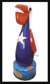
Lone Star Pelican
In May 2001 6-8 ft. artistically embellished fiberglass pelicans began appearing in front of various establishments and even the Seabrook City Hall. The pelicans are known to have origin from the Pelican Path Project. The Lone Star Pelican showed here is usually in front of city hall, except every now and then he leaves his roost for special events. The goal of the Pelican Path Project has been to improve Seabrook’s visibility and identity as a community enhanced by its strong ecotourism, quiet family lifestyle, water recreation, and its quaint small businesses. Seabrook is in the center of the third largest boating community in the country, and with that comes a multitude of boating, fishing, and other water sports activities as well as the nature and birding opportunities.
The history of Clear Lake City, Houston, TX
One would be remiss in writing of the history of Clear Lake City, TX without mentioning James Marion West, cattle baron of East Texas. West had been born in Mississippi in 1871; he came to Texas with his family when he was nine years old. Going to work as a water-boy at the age of 13, West's scrappy beginnings coupled with his success as a Texas business legend, rancher and oilman constitute the stuff legends are made of.
Nicknamed "Silver Dollar Jim" because of his propensity to throw coins to passersby, West owned a fleet of 30 Cadillacs which he kept in downtown Houston. Each car had an arsenal of 30-35 guns; certainly Jim West was the quintessential, stereotypical eccentric oilman.
Initially, however, West made his fortune in lumber, forming the West Lumber Company, which prospered during World War I. When the first Great War was over, he began to diversify by investing in ranches and cattle throughout the state.
He invested in a number of Longhorn cattle, establishing his reputation throughout Texas during the 1920s. After returning from a trip to Europe in 1924, West built a forty room mansion for his family on property he owned on Clear Creek. The Italian Renaissance- style, palatial home was the talk of Southeast Texas.
According to Texas historians, West foresaw the Depression, leveraging his assets in preparation for the economic downturn. In 1931, he discovered oil on the Clear Creek property. Never one to allow sentiment to cloud his business acumen, he sold the thirty thousand acres (what is now Clear Lake City) the mansion sat on to Humble Oil Company (now Exxon) for the sum of 8.5 million dollars. One can only imagine the royalties West earned in the years prior to his death.
Like many small, South Texas communities at the time, oil built Clear Lake City. Lying between Harris and Galveston Counties, two oilfields were developed there following the Humble Oil purchase: Clear Creek and Friendswood. In 1958, Humble donated some of the land to Rice University for a geology lab.
Clear Lake really came into its own in the early 1960s, going on to become one of the largest planned communities in the Houston area. In 1962, Humble teamed up with the Del Webb Corporation and developed 15, 000 acres for residential and industrial use. Governor John Connelly formally opened Clear Lake City in 1963.
In 1961, Rice was given a larger tract, which was donated to NASA, and is where the Johnson Space Center is now located.
Despite its oil refinery history, Clear Lake City was not crippled by the oil crash of the mid-1980s. By that time, there was a wide range of economic diversity; aerospace engineering was an economic mainstay.
Short History of Webster, Texas
The community was founded in 1879 by James W. Webster under the name Gardentown. It was established initially as a colony for settlers from England. It began as a stopover for travelers between Houston/Harrisburg, Galveston, Kemah, and Seabrook. Eventually railroads, such as the Missouri, Kansas and Texas Railway, were built through the area. Farmers in the area raised pears and other produce.
Dairies and livestock ranches developed in the town as well in the early 1900s. Petroleum was discovered at the Webster-Friendswood Oilfield in the 1930s but the population remained small. The small community was incorporated in 1958.
In 1903, the Houston Chamber of Commerce invited Seito Saibara, a former Japanese member of parliament and a Christian theologian, to come to Texas to teach rice farming. Rice at that time was emerging as an important cash crop. Saibara settled in Webster with and established a small farming community of Japanese Christians. Saibara and his son Kiyoaki established the foundations of what became the rice industry of the U.S. Gulf Coast.
In 1961 the National Aeronautics and Space Administration announced that it was building the Manned Space Center (now known as the Johnson Space Center) nearby along the shores of Clear Lake. Growth and development quickly swept over the Clear Lake Area and Webster's population blossomed.[3] Webster today has become a thriving bedroom community closely tied to the Clear Lake Area and its high-tech industry.
History of Nassau Bay, Texas
Early History
Prior to the construction of the Manned Space Center, what is today Nassau Bay was ranch land in the unincorporated southernmost portion of Harris County. The nearest cities were Webster, League City, and Seabrook. In 1962, a community was planned which would be an exclusive residential and commercial area emphasizing its pioneers and at a then-staggering cost of $49 million.
From 1927 to 1962, most of Nassau Bay was part of the 1776 Ranch owned by Colonel Raymond Pearson. Colonel Pearson of Houston sold the 570-acre 1776 ranch to Jack Kamin's group of developers. The plan was to build Nassau Bay in the middle of raw acreage ranch land adjacent to the National Aeronautics and Space Administration's laboratory, the only planned development in the area.
Nassau Bay's Name
The name was chosen by the original developers of raw land known as Colonel Pearson's 1776 Ranch. Our historian reports that the developers chose the name because of the tropical feeling it generates. At the time, NASA was moving personnel from several areas in the United States with a high quality of life, including California and notably, Florida.
| Appetizers |
| Meat |
| Poultry |
| Beverages |
| Seafood |
| Holiday Recipes |
| Desserts |